
KORSMAN CONSERVANCY
HISTORY Part 1
OVERVIEW
The pan was first known as Westdene Pan and expansion of Benoni started around it in the 1920s. In the 1950s, the Pan was fenced to protect bird life and was later declared a nature reserve. Game were introduced and were a popular attraction at Korsman for four decades.
Since the 1980s, volunteers have worked to preserve Korsman for future generations.
The Sanctuary is still owned by Ekurhuleni Metropolitan Municipality.
Historical information and photographs provided by Anne Mearns, Dian Cockroft, Cedric Ostermeyer, Alison Bainbridge, Glynis Millet-Clay of 'Benoni History' Facebook group, Peter Wood, Stephen Rehbock, Benoni City Times archives.
1. Westdene Pan: Early days
The first users of the Pan may have been hunter-gatherers, as artefacts found just a couple of kilometres away shows they inhabited the area several thousand years ago. When Trekboers established farms in the area in the early 1800s, they found no human settlements.
In the early 1900s, the open pan was part of the farm Benoni, a portion of unclaimed land in between other farms, and upon which the town was established.
Westdene Pan first came into the news in August 1909, when at the end of a two-day snowstorm in Benoni, a large flock of ducks settled on the pan and were hunted by anyone who could get hold of a shotgun.
The southern side of the pan was used for sand mining then as a rubbish dump site of the newly formed town. It had the appearance of a battlefield where rubbish had filled the holes made by mining. Boys used to find discarded metal sheets to build canoes, planks for the paddles, and race across the pan. Many years later, residents digging holes in their gardens could come across bits of bicycle or an ancient gramophone. Even now inside the Sanctuary area, ash heaps instead of soil are sometimes pushed up by moles.
Exotic trees such as bluegum, pine, poplars and swamp cypress were planted at the pan after the Council requested residents to plant trees around Benoni. Some of the bluegums still grow in the Sanctuary.
In 1910, a makeshift abbatoir known as a 'slaughter pole' was erected on the north-east bank and used until 1913 when the Council built the first abbatoir.
In 1920, 70 stands were laid out in Westdene, with many around the pan area. The first residents were allowed to shoot the wild duck for sport and dogs in the area hunted and killed the waterfowl. On the west side was O'Briens farm, whose cattle and sheep grazed and watered at the pan.
2. Memories of a childhood
Cedric Ostermeyer related how his father, Arthur Joseph Ostermeyer, built one of the first houses in the new suburb in 1929 at 41 Edward St. It was the second house in the road and he was asked why he was building “out there”, as the area was still undeveloped. Edward St was only paved to their corner with a dirt road beyond. The house roof blew off in a cyclone that passed through Westdene in 1930.
The Ostermeyer house had a wonderful view of the Pan from the back porch, where the family ate, and Cedric remembers how the pan water looked gold in the sunsets. The property had a large vegetable garden, but the cows from O'Briens farm wandered across and ate the Ostermeyer's vegetables, and the bull once chased Cedric and his pals.
At the top of Victoria Ave there was an open storm water drain into which the kids climbed with their go-karts and rode it down to near the water. This activity was popular enough to last through generations, as Alison Archibald Bainbridge (who grew up on the western side, developed later) also rode the storm water drain as a child, in the 1950s.
Cedric and his friends played around the pan. They paddled their canoes and plugged the screws with melted tar from the road on hot days. The water was 7-8 feet deep and crystal clear. They built a jetty of stones out into the water near Short St.
It become a rite of passage for admission into the local gang to swim across the dam. Cedric once attempted it and got three-quarters of the way across but thought he wouldn't make it, so turned around and swam back. The kids had all run around to wait for him and then came back to ask what had happened. It taught him the lesson that you must keep on going.
The worst part of wading in the dam was the bloodsuckers – leeches – which attached to their legs and feet. There were plenty of snakes and bullfrogs. There was a stand of reeds near Sanctuary Lane where they went in their canoes and raided bird's nests for eggs. Cedric's mother disapproved so Cedric didn't collect, but the other boys blew their eggs out and built up large collections.
The kids used to picnic at the Victoria St rockery and collected the little 'elephant feet' succulents which he found afterward were rare (probably Lithops). The rockery was later developed as an enclosed garden, where one could enter through a gate.
The Drive, initially a gravel road, was built up later, with the more affluent area of the time on the south-eastern / Sanctuary Lane side.
3
. Conserving the Pan from 1953 – Korsman Bird Park
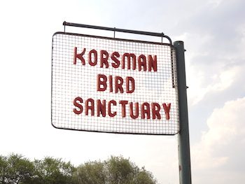
Nic Korsman, a town councillor (and co-founder of Korsmans Ice Cream factory) resident in Sunny Rd, walked his dogs at the pan every day. A great admirer of birdlife, he was dismayed to see how many birds were being killed by dogs and initiated a project to fence the pan area to protect the bird life. He met with the Town Engineer, Mr. Smith, and Head of Parks, Mr. Dubbeld, who were astonished by the great diversity of waterfowl at the pan. The fencing was completed in 1956 and the area was named “Korsman Bird Park” after the originator. In 1967, Korsman Bird Park was declared Korsman Bird Sanctuary by the Transvaal Department of Nature Conservation.
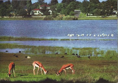
Over the following years, plants and various game species were introduced. In 1954, reeds, bulrushes and exotic trees were planted at the pan, eventually changing the habitat from grassland to mixed grassland and woodland.
An artificial island was made by bulldozers in the centre of the pan in about 1952, when the pan was dry. Although the surface seemed solid, one of the bulldozers broke through the dry crust into the sticky mud and was recovered with great difficulty. A stone causeway was later built to the island and is visible when the water level is low. The island is now underwater and has reed growth showing its location.

1929: Westdene Pan in the background on the left. Seen from 41 Edward St under construction.
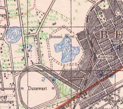
1930s Benoni map
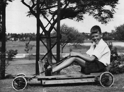
1950s: Pan in the background, R, from the Kilfenora side. (NB Not the go-kart used in the stormwater drain!)
1980s: View of The Drive from inside the pan
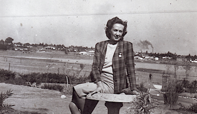
1930s: View from 48 The Drive
1982: Image from Benoni 75 year publication,
looking towards Divot St.


